 Waurkika Lake was no exception. As is usual for this time of year we nearly had the campground to ourselves and found a nice spot right on the water. The weather called for a bit of wind so we did some laundry A' La John Steinbeck (See "Travels with Charlie") and hung it out to dry on the little Ramada provided at the campsite and went to bed. Cheryl awoke with a start an hour or so later to find a 45 MPH wind blowing our laundry straight out. It was fortunate that no one was around to see us scrambling around in our PJs taking down the laundry in the middle of the night. And it was dry. The lake was whipped up to a frenzy the following morning.
 Anybody care to guess how high that bluff over the lake is? I think Cheryl should have taken a picture of me while I was over there, but she didn't. (Answer at the end of the post) Knowing we would be facing that wind all day we pulled out early for Texas.
We hit the Texas border, dead into the wind with the dust blowing and Willie blasting on the CD player. I'm sure we did our Son-in-law Scott proud as he's a big Willie Nelson fan. We were headed for Caprock Canyon State Park in the Texas Panhandle.  We didn't realize that this was cotton growing country until we started to see the plants, many of which still had some of last years crop clinging to them.
 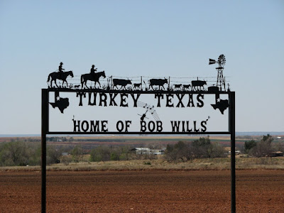 Heading north to Caprock Canyon we passed through Turkey, Texas, home of the famous Bob Wills, one of the originals of Texas Swing music. We didn't have any Bob Wills, so Lyle Lovett had to suffice.

This a special picture for our friend Connor who is almost 7, likes trucks, and whose favorite color is red We didn't realize that this was cotton growing country until we started to see the plants, many of which still had some of last years crop clinging to them.
  Heading north to Caprock Canyon we passed through Turkey, Texas, home of the famous Bob Wills, one of the originals of Texas Swing music. We didn't have any Bob Wills, so Lyle Lovett had to suffice.
Caprock Canyons is a beautiful park with lots of mule deer, lizards, soaring birds and gorgeous red rock canyons.  This is a Blue Bellied lizard, very common in red rock country. (About 4" long)
We stayed 2 days and did some serious hiking. We left early one day for a hike out a trail to take us up to a high point overlooking the canyon, but as often happens to us we got distracted. We knew that the Red River, which is a dry wash this time of year, crossed the trail at several points.  This is a Blue Bellied lizard, very common in red rock country. (About 4" long)
 So, we decided to hike up the river for a while. Before intersecting the trail we found several dry washes coming in from side canyons.
 The white stuff you see layered in the rock is Gypsum, sometimes the layers will be almost a foot thick. One of these washes led up to the head of a box canyon with great views we never would have seen from the trail.
  We ended up hiking 4.8 miles in 5 hours, and felt like we hiked 20. Caprock Canyons is the home of the Official Texas Buffalo herd but we never saw them. It's a big park.
From Caprocks Canyon we headed west, again fighting the wind (we averaged around 10MPG for these 3 days - well below our usual 12 - 13 MPG) for Manzano State park in Mountainair, New Mexico.
 I'll tell you what, West Texas and East New Mexico are FLAT ! I swear you can see the curvature of the earth. And there are lots of tumblin' tumbleweeds. Approaching Mountainair we once again headed up into mountains, which we like. We followed a couple of Forest Service roads to the park and found at the gate that Red Canyon, a Forest Service CG, was open so we drove up another 3 miles and found a gem.
 The entrance sign was posted with Black Bear and Cougar alerts. We like places like this.
  Since the campground, situated in a Ponderosa Pine forest, is National Forest, we could gather wood and had a great campfire (Can you say S'Mores). In the morning we hiked up to 8200 feet to the Ox Trail dispersed camping area to get a hunger going... it worked.
Prior to leaving we chatted with a couple of NFS rangers who were passing through the campground doing a timber survey. There had been a fire in the area last year and they were finding "hazard trees" that needed to be removed. I can't say enough good about the wonderful people who serve in our National Forest and National Park services. They are dedicated professionals with a lot of hard work to do and yet they still always find time to answer the questions of people like us who travel these areas. When you pass through one of our nations great parks, or minor forests, give them a shout out whenever you can. They deserve to know we care. We left Red Canyon for the Sitgreaves National Forest in Arizona after filling up with water at the NF ranger station in Mountainair.
 We passed through Pietown, New Mexico, but to my vexation it was closed. I'll bet that pie would have been good. We were now seriously in the mountains, and the wind, as we lugged our way into Arizona. Due to an oversight (ours, not theirs) the Campgrounds we were headed for were closed so we found a trail head parking lot at Pole Knoll and spent a night stealth camping.
 This is Arizona ?
Oh Yeah, the bluff at Waurika lake, 30 inches high, no lie.
Next: down through the Salt River Canyon to the Salt River Recreation Area (BLM lands...Free Camping,) to meet our friends Mr & Mrs. Whazoo.


