Thursday, April 28, 2011

Lake Powell - AZ, UT

Camping at Lone Rock Beach on Lake Powell

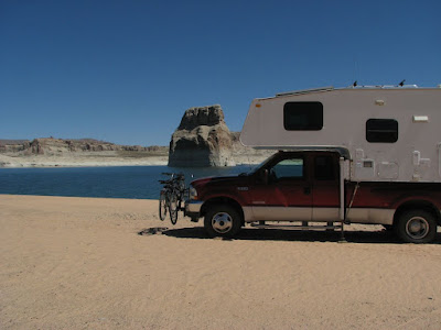
How would you like to wake up to this view every morning?
This is the view from the camper on Lone Rock Beach in the Glen Canyon National Recreation area of Utah and Arizona.  We decided it was time for a change of scenery, and perhaps a bit of kayaking.  Lake Powell is the the lake that formed when the Glen Canyon Dam, completed in 1963, flooded Glen Canyon.  To this day there is still much controversy about the Glen Canyon Dam.  Many people feel that it took away one of the most beautiful canyons in the world to put golf courses in the desert.  I can't speak knowledgeably to that question, but I can say that Lake Powell is a supremely beautiful place and I can believe that Glen Canyon must have been awesome.


Lone Rock Cave
We set up right on the beach with a beautiful view of Lone Rock on the Wahweap Bay arm of Lake Powell in Utah.  

The beach is huge and, at this time of the year, pretty much empty.   


We haven't done much beach camping and it was a real thrill for us to be here.


We set off the first day to explore Lone Rock and the far shore of the bay.

With no trees or familiar landmarks to provide an anchor for perception, the distances on Lake Powell are very deceiving.  Lone Rock looked to be about ½ mile away.  It took us 45 minutes to paddle to the rock, probably about 1½ to 2 miles.


On the far shore, invisible from our campsite, we found a small bay that led into a delightful slot canyon that we could kayak into.  At times we could put our hands on both sides of the canyon and push our kayaks through.


On our second day we kayaked to Castle Rock, an island near the center of Wahweap Bay, about a 6 mile trip one way, but well worth the effort.  The beautifully clear water, next to those towering white and red rock cliffs is just spectacular to see.


As you can see I am taking life seriously here in the west and working hard to have a good time.        ⇒


⇐ Another cave.  This one appeared to be about 12 feet deep to the cave floor, but with the water level where it was I could just barely fit into it.


Back at the campsite, just before the big wind that was due to show up, we shared a campfire with a wonderful family from Switzerland.  They are on sabbatical, 10 months into a 12 month tour of the US, Mexico and Canada.  They have seen more of the US in 10 months than most Americans will see in a lifetime.  It must have been a terribly difficult decision to come to a foreign country, buy a truck and fifth wheel camper, and set off on their own, touring Cities, National Parks and Forests, and meeting lots of new friends along the way.  Cheryl and I are very proud to know them .

Eddy, Jenny, Cindy, Aline
Bon Voyage


We have been so blessed in our travels to meet  some of the world's nicest people.  

Well, shortly after the campfire the promised big wind showed up and blew us all the way north to Bryce Canyon National Park...More to come.


Monday, April 25, 2011

Toroweap Overlook - Grand Canyon National Park, AZ


2011 Western Trip
Toroweap – Grand Canyon National Park

Scratch one off the Bucket List
I can remember as a kid seeing pictures of Toroweap in National Geographic Magazines and other books on the American West. I was instantly fascinated and always hoped to see this remote, but spectacular, part of the Grand Canyon. Lately, with all our traveling about I have often looked at the information regarding Toroweap that I have been saving, knowing it was unlikely we would ever get there. Last year, while visiting Pipe Spring National Monument in Arizona we drove by the road to Toroweap, but it is a difficult place to get to and we had other places to go. 
This year we found ourselves once again at the road to Toroweap. We stopped for lunch on the way to Kanab at the pull off for Antelope Valley road...the road to Toroweap. The road, unimproved of course, is 61 miles long, the last 20 miles is rough, the last 6 miles is over slickrock, narrow and difficult, and the last 3 miles requires a high clearance 4 wheel drive vehicle. I stopped a couple of people coming out of the road for information and they all said the road was in great shape, but they had not been all the way out to the campground, 61 miles away. Awww. What the hell. We've done bad roads before. 

 
We did 28 miles of gravel road to get into City of Rocks National Monument. We did 56 miles of gravel road to visit Ruby Marsh National Wildlife Refuge. I know a guy who did over 600 miles of gravel road to visit James Bay.

In truth, the road was in very good shape for 40 miles, and really pretty good still for another 15 miles. Miles 56 through 58 were rough, but we did much worse going out to visit some of the Ancient Puebloan Ruins we visited 2 years ago. Now miles 59-61 were tough. They were narrow twisty slickrock miles with tight gaps (9 feet ! - 8 foot truck), but we shifted down into 4 wheel drive low range, took it real slow, me driving and Cheryl moving an occasional badly positioned rock, and very carefully made it to the campground to claim the last available site. It took us 45 minutes to do the last 3 miles, about 3 hours total. Was it worth it.          Take a look.  ⇓
Canyon View from Toroweap
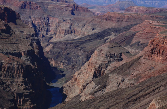
Toroweap Outlook is almost straight above the Colorado River in a geologically active area. This is the area where an ancient lava flow dammed up the river until the river finally cut through it and created Lava Falls, one of the toughest sections of the river for rafters and kayakers, reputedly a 36 foot drop. From most of the public areas of the Grand Canyon it is very difficult to see the river that created the canyon.  Mile long drops, and canyon walls that descend to the river in wide steps, hide the river from the rim for most of it's journey.  By contrast, the near vertical canyon walls of Toroweap make it much easier to see the river..if you don't mind leaning out a bit over the edge.

Colorado River, Grand Canyon, from Toroweap Overlook.
Most photographers know that the early morning hours and the magic hours before sunset are the time for spectacular pictures.  Cheryl is no exception.
Mount Sinyella at Sunrise.

Mount Sinyella at Sunset
We've been to both the North Rim and South Rim sections of the Grand Canyon. The South Rim is big, with huge vistas looking down miles of canyon. The North Rim is a much more intimate area, less developed, forested, and very beautiful. Toroweap, some 50 or so miles west of the North Rim, and probably 80 or 90 miles downriver, is a bit of both. We are lower here, only 3000 feet above the river, but we are also in the Canyon rather than on the rim looking down into it. You feel the canyon more here. Many of the viewpoints are truly vertical above the river unlike the stepped drops to the river farther up canyon. If the expression “Willie Knees” means anything to you, be prepared for a lot of that feeling at Toroweap.

Hangover


Show Off.


We camped for 6 days at  Toroweap (mostly because I was not looking forward to the drive back out - Just Kidding) and hiked every day.  The campground, operated by the National Park Service, is free to anyone willing to make the trip. Pack it in – Pack it out, of course. That's just perfect for a truck camper.
Settled in at Toroweap Campground.
All of the venues of the Grand Canyon (Lee's Ferry, Cathedral Wash, North Rim, South Rim, Toroweap) are magnificent and whenever you get the chance to visit any of them you will be amazed, but in my humble opinion, Toroweap is by far the best. 
6 Days was enough to make us want to come back.


⇐ YIKES !


Friday, April 15, 2011

Dispersed Camping - BLM, National Forests


View from dispersed campsite - BLM -Virgin River Recreation Area

The BLM (Bureau of Land Management), the agency that oversees much of the Public Land in the west and the National Forest Service provide many developed camping areas in the western US.  Unlike the National Park Service they also allow what is known as dispersed camping.  That is camping along gravel roads and in primitive campsites throughout the public lands.  Dispersed camping areas do not have facilities... no picnic tables, no bathrooms, no rec centers, no hookups.  You are on your own and you must be either self-contained like we are (we have a bathroom and holding tanks for our waste water and plenty of fresh water) or use proper back-country disposal methods (or in some cases pack it in - pack it out).  Along with all those don't haves, these areas do have, unspoiled beauty, solitude, quiet, dark skies and the chance to see wildlife in it's natural setting.
Just us and the Joshua Trees.

We are currently camped in Northwestern Arizona amidst Joshua Trees and lots of cactus and lizards.

The beauty of dispersed camping (besides the fact that it is free) is that you can camp in amazing places,  usually without the sound of traffic, and always without the sounds of generators and radios.


Looking North toward Utah


This site is one of the best we've ever found, with 10 mile views of the sandstone cliffs of Utah and a myriad of blooming Desert plants.

We are fortunate that the BLM and Forest Service allow this kind of camping and we always take care to leave the site cleaner than we found it.  It is our hope that all will do so and we can all continue to take advantage of this marvelous recreational resource.

Looking Down on Our Campsite from the Cliffs to the West.

Last year we were fortunate to find a couple of excellent dispersed site.  Here we are camped at the BLM Paria River area on the southern border of Utah near Lake Powell.


Leavitt Creek, California


Above we are camped on the banks of Leavitt Creek in the Stanislaw National Forest, in the Sierras of California.

Dispersed camping is one of the joys of the west, and while we will continue to explore our National Parks and Forests, we will always look for the out of the way places where we can spend a few days alone in the wilderness.

Tuesday, April 12, 2011

Zion National Park, Utah

Hiking to Observation Point
 We visited Zion National Park 14 years ago, when automobiles were still allowed on the park road.  It was busy, cars were jammed up trying to get into parking lots, and the smell of exhaust was everywhere.  In 2000, the Park Service made the decision to restrict auto travel and set up a shuttle service to transport visitors into and out of Zion Canyon.  Today only bicyclists and shuttle buses use the 7 mile road from Canyon Junction to the Temple of Sinawava at the top of the Canyon


The waterfall at Temple of Sinawava


As we would only be here for two days we wanted to do something really special.  We had climbed the Park's premier hike "Angel's Landing" in 1997.  On the afternoon we arrived we unpacked the bikes and rode up the canyon to check possible hikes.  With no cars, the ride was marvelous, definitely a first rate way to see Zion Canyon.  We found the hike... Observation Point.  The hike is 8 miles round trip, with an elevation gain of 2,100 feet, up about 4 million switchbacks stuck like goat paths along the canyon walls.
The Hike to Observation Point.


After the first set of switchbacks (seen above) the trail enters Echo Canyon.  We had to remove our shoes and wade through this part of the canyon.


The trail follows above the true slot canyon that is Echo Canyon.  Skilled Canyoneers navigate the slot with rappelling ropes and wetsuits, but we were satisfied to walk along above it in the warm sunshine.
Echo Canyon

Looking Back Through Echo Canyon
 After Echo Canyon the trial widens for a while, then continues up switchback after switchback to a plateau above Zion Canyon
Zion Canyon from Observation Point Trail


Zion Canyon from Observation Point - Angel's Landing in the Foreground.


Angel's Landing is the point at the far left of the narrow fin seen in the foreground.  The hike up that knife edge is one that any hiker will remember for life.  If you ever get to Zion NP, and have the time, take the hike to Angel's landing.  If you have the time, and a lot of stamina, take the hike to Observation Point.


⇐  Waterfall over the Weeping Wall.


We were very lucky to see this fall at such full flow.  This waterfall is the outflow of the creek through Echo Canyon.


Zion National Park, one of our first National Parks, was established as a National Monument in 1909 and as a National Park in 1919.  The 7 mile long canyon, walled by huge sandstone towers, is unique in the world, and a must see in the southwest US.