2011 Western Trip
Toroweap – Grand Canyon National Park
Scratch one off the Bucket List
I can remember as a kid seeing pictures of Toroweap in National Geographic Magazines and other books on the American West. I was instantly fascinated and always hoped to see this remote, but spectacular, part of the Grand Canyon. Lately, with all our traveling about I have often looked at the information regarding Toroweap that I have been saving, knowing it was unlikely we would ever get there. Last year, while visiting Pipe Spring National Monument in Arizona we drove by the road to Toroweap, but it is a difficult place to get to and we had other places to go.
 This year we found ourselves once again at the road to Toroweap. We stopped for lunch on the way to Kanab at the pull off for Antelope Valley road...the road to Toroweap. The road, unimproved of course, is 61 miles long, the last 20 miles is rough, the last 6 miles is over slickrock, narrow and difficult, and the last 3 miles requires a high clearance 4 wheel drive vehicle. I stopped a couple of people coming out of the road for information and they all said the road was in great shape, but they had not been all the way out to the campground, 61 miles away. Awww. What the hell. We've done bad roads before.
We did 28 miles of gravel road to get into City of Rocks National Monument. We did 56 miles of gravel road to visit Ruby Marsh National Wildlife Refuge. I know a guy who did over 600 miles of gravel road to visit James Bay.
In truth, the road was in very good shape for 40 miles, and really pretty good still for another 15 miles. Miles 56 through 58 were rough, but we did much worse going out to visit some of the Ancient Puebloan Ruins we visited 2 years ago. Now miles 59-61 were tough. They were narrow twisty slickrock miles with tight gaps (9 feet ! - 8 foot truck), but we shifted down into 4 wheel drive low range, took it real slow, me driving and Cheryl moving an occasional badly positioned rock, and very carefully made it to the campground to claim the last available site. It took us 45 minutes to do the last 3 miles, about 3 hours total. Was it worth it. Take a look. ⇓
 |
| Canyon View from Toroweap |
Toroweap Outlook is almost straight above the Colorado River in a geologically active area. This is the area where an ancient lava flow dammed up the river until the river finally cut through it and created Lava Falls, one of the toughest sections of the river for rafters and kayakers, reputedly a 36 foot drop. From most of the public areas of the Grand Canyon it is very difficult to see the river that created the canyon. Mile long drops, and canyon walls that descend to the river in wide steps, hide the river from the rim for most of it's journey. By contrast, the near vertical canyon walls of Toroweap make it much easier to see the river..if you don't mind leaning out a bit over the edge.
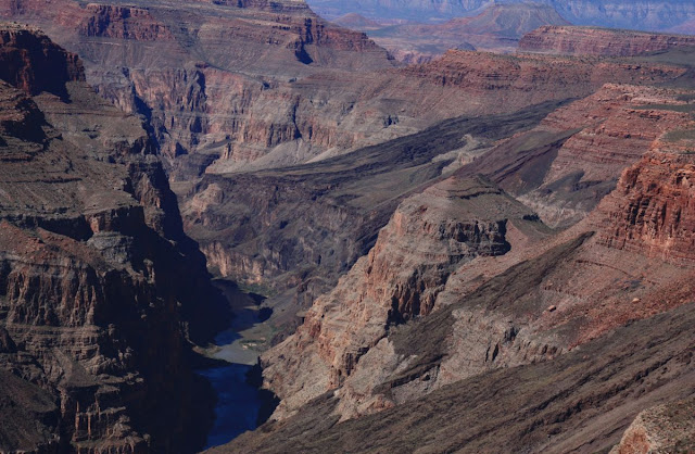 |
Colorado River, Grand Canyon, from Toroweap Overlook. |
Most photographers know that the early morning hours and the magic hours before sunset are the time for spectacular pictures. Cheryl is no exception.
 |
| Mount Sinyella at Sunrise. |
 |
| Mount Sinyella at Sunset |
We've been to both the North Rim and South Rim sections of the Grand Canyon. The South Rim is big, with huge vistas looking down miles of canyon. The North Rim is a much more intimate area, less developed, forested, and very beautiful. Toroweap, some 50 or so miles west of the North Rim, and probably 80 or 90 miles downriver, is a bit of both. We are lower here, only 3000 feet above the river, but we are also in the Canyon rather than on the rim looking down into it. You feel the canyon more here. Many of the viewpoints are truly vertical above the river unlike the stepped drops to the river farther up canyon. If the expression “Willie Knees” means anything to you, be prepared for a lot of that feeling at Toroweap.
 |
| Hangover |
⇒
Show Off.
We camped for 6 days at Toroweap (mostly because I was not looking forward to the drive back out - Just Kidding) and hiked every day. The campground, operated by the National Park Service, is free to anyone willing to make the trip. Pack it in – Pack it out, of course. That's just perfect for a truck camper.
 |
| Settled in at Toroweap Campground. |
All of the venues of the Grand Canyon (Lee's Ferry, Cathedral Wash, North Rim, South Rim, Toroweap) are magnificent and whenever you get the chance to visit any of them you will be amazed, but in my humble opinion, Toroweap is by far the best.
6 Days was enough to make us want to come back.
⇐ YIKES !
 Chisos Basin Warning Sign.
 The weather was just too darn hot in Rio Grande Village (100+℉) so we were back up at Chisos Basin for a couple more days. One last important hike remained and that was the Santa Elena Canyon at the western edge of the park. We took the camper off and drove the 30 miles to the trailhead in the truck.


 Prickly Pear.
 The Many Layers of Big Bend.
 The "Mules Ears".

 Campsite at Rio Grande Village - Big Bend NP
 Ocatilla and Prickly Pear above the Rio Grande River
 On our second day the temperatures were in the upper 90s but we decided to hike to the Rio Grande Hot Springs anyways. We had plenty of water and food, dressed appropriately for the hike and set out around 10:00AM. We found a couple of real treasures along the way.
 Cliff Swallow's mud houses.
 A Cephalapod Fossil, still encased in rock.
 The hot springs were quite fashionable at one time, with bathhouses, a cafe, and some lodging, but all that remains today are the shells of the old buildings and this riverside spring. A hot soak at 105℉ wasn't too appealing to us after a hot and dusty 3 mile hike, with another 3 to go to get back to the campground, but there were folks there enjoying the spring.


 Old Barn at homestead in Great Smoky Mountains National Park.

 and Shiloh National Military Park, also in Tennessee


 Cheryl and Bruce on Full Moon Bridge - Garvan Woodland Gardens, Arkansas


